Tongass National Forest, forest region and wilderness area in southeastern Alaska, U.S. It was established in 1907 by an executive order issued by Pres. Theodore Roosevelt (formal legislation declaring it a national forest was signed into law in 1909). Tongass National Forest covers most of the Alaska panhandle and is the largest publicly owned forest in the United States. The forest was named for a Tlingit Indian group. Its approximately 26,560 square miles (68,790 square km), composed of (volcanic) mountainous offshore archipelagos and rugged fjord-indented coastline, include some of the most extensive intact remnants of virgin temperate rainforest in North America. Misty Fjords (or Fiords) and Admiralty Island national monuments are located within the forest.
Found in association with barren alpine tundra (above the tree line), lowland muskeg, and scores of tidewater glaciers that descend to the coastline, the forest is dominated by towering species of western hemlock and Sitka spruce. Its rich understory includes blueberries, skunk cabbages, and a profusion of ferns and mosses. Brown and black bears, Sitka black-tailed deer, wolves, mountain goats, river otters, mink, northern flying squirrels, seals, and numerous species of birds—including bald eagles, northern goshawks, and the elusive marbled murrelet—are part of the unusual variety of wildlife. Approximately one-third of Tongass has been protected as a national wilderness area, and about one-fifth has been designated for commercial development. The forest has long been the centre of intense conflict between conservationists and logging companies. Fishing and tourism are the forest’s most significant economic activities.
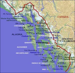
Alexander Archipelago, group of about 1,100 islands (actually the tops of a submerged section of the Coast Ranges) off the coast of southeastern Alaska, U.S. Named by the U.S. Coast and Geodetic Survey in 1867 to honour Alexander II, tsar of Russia, the islands are included within the Tongass National Forest and extend southward from Glacier Bay and Cross Sound to the Dixon Entrance. Among the largest islands (north-south) are Chichagof, Admiralty, Baranof, Kupreanof, Kuiu, Mitkof, Wrangell, Prince of Wales, and Revillagigedo. The chief cities are Sitka on Baranof and Ketchikan on Revillagigedo, and the islands are chiefly supported by lumbering, fishing, fur collecting, and mining. They were once the exclusive home of Tlingit and Haida Indians (especially noted for their totem poles). The irregular shorelines of the islands are separated from the mainland by deep, narrow channels that form part of the picturesque Alaska Marine Highway system, or Inside Passage. Glacier Bay National Park and Preserve forms part of the archipelago and, together with Kluane National Park and Reserve (Yukon, Canada), Wrangell–St. Elias National Park and Preserve (Alaska, U.S.), and Tatshenshini-Alsek National Park (British Columbia, Canada), it comprises a World Heritage site, part of the largest internationally protected area in the world. Sitka National Historical Park and Misty Fjords and Admiralty national monuments are also within the archipelago.
My greatest gift is watching the faces of my guests as they experience the wonders of Alaska. Cap